After two weeks without kayaking, Saturday's paddle whetted my appetite for some serious conditions. Since it was looking like trouble was bound to break out, H wisely decided to stay home and made me promise not to get too hurt. Further increasing the probability of trouble, the weather was full of wind and rain and I woke up in a particularly ornery mood.
I showed up for the 10am launch just before 9am hoping to get a good parking spot and a nap. Both goals were foiled. The parking lot was full of cars from the divers who frequent Ft. Wetherill and a few paddlers had not checked to message board to see that the paddle had been postponed until 10am. It was probably for the best since I still had trouble getting ready on time....
One of the early birds was Jerry B., who had his new Night Heron. She is a beautiful looking kayak. Jerry's modesty aside, he did a wonderful job crafting her. The angled pattern on the hull and the shine of the hull speak to the patience and care that went into the work.
With amazing speed, the group of paddlers swelled to seventeen!! The less than auspicious weather was not dampening anyone's spirits. In fact, there were a few people who came looking for some rough water paddling.
Joe, who was substituting for Frank M., decided that conditions called for a safer plan. He, despite offering up rough water options, intended to take the group along the shore by Fort Adams where there would be plenty of protection. Given the size and composition of the group, his plan was definitely the correct one, if not the most popular one.
To mollify us danger seekers, or perhaps hoping to scare us straight, Joe lead the group out of the Ft. Wetherill cove and crossed to Castle Hill Light. With some cajoling, Joe kept the group in a tight formation across the channel. Once at Castle Hill, he stopped the group so people could get a look at the conditions in the outer bay. Since most of the group knew the plan they stayed close to the shore waiting to paddle towards Fort Adams.
Spotting the danger lust in my eyes, Joe told me that I could, if I wanted, form a break away group. Unfortunately, the only people who had ventured out to take a look was a paddler I didn't know, Matt, and Eli. I decided that, given my options, it was wisest to stick with the group and headed back.
While I was making my way back to the group, Tim M. was making his way towards the point. He wanted to take a peak at the conditions just beyond the point, so I turned tail and headed out with him. The original plan was just to take a peak and then return. Then we noticed that Eli and Matt were tagging along and Paul B. was rapidly catching up.
Since we now had a group, and Joe had given me permission to form a breakaway group, we headed off to Brenton Point to see what trouble could be had. Tim and I really wanted to see what our new kayaks were like in bigger conditions. Matt, it turned out, also had a new kayak, a full sized Nordkapp, that he wanted to feel out. Paul and Eli were just out for some fun.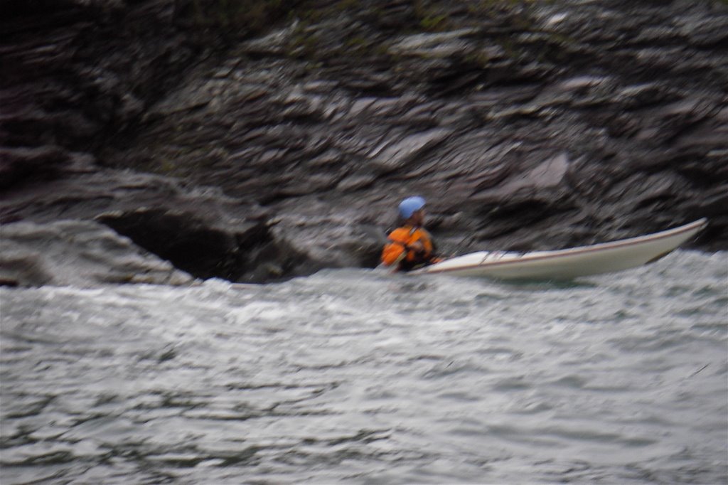 We paddled about 3/4 of the way to the point battling some pretty heavy winds and chop. Then we moved a little further off shore to really get into the swells and turned back towards Castle Hill to catch the following seas. Despite looking like he was riding a rabid horse with the shakes, Tim handled his new kayak, which he has dubbed "the devil boat", with aplomb. We all caught several good rides on the generous swell.
On our way back towards Castle Hill we spotted another group of paddlers heading out for trouble. Ken, Becca, and Carole had left the main group once they realized others had also wandered away. After dressing us down for not telling the main group we were leaving and not asking them to join in our adventures, they joined us and we headed back towards Breton Point.
As Becca pointed out, it was hardly fair of us to hog all the good conditions for ourselves. It's not like there are a ton of opportunities for RI paddlers to enjoy some rough stuff. As we wended our way back to Brenton Point, we took turns dodging rocks. The game of choice was to back the kayaks into a rock formation, try to touch the tail to the rock, and hang out for as long as possible. We also found just about every navigable slot along the shore to dart through. It was great boat handling practice.
Once back at Brenton Point, we found some real fun. Along the break water that juts out from the point, the water was really rough. The swells piled into each other and the reflection off of the wall created some clapotis. It was exactly the kind of conditions a smart mariner avoids and a kayaker seeks out.
I dashed in and the waves pretty much submerged the Q-Boat. I'd gotten used to its stearn having water over it during the course of the morning. Any wave over six inches covers it. The Q-Boat's bow, which is like a gigantic bubble, had been pretty dry until I tested my luck. Luckily for me, the Q-Boat is, like its little sister the Anas Acuta, as stable as a six legged table that is bolted to a two ton piece of granite. I dashed out just as quick.
Tim M. had a different idea. He was feeling pretty good about his handling of the devil boat and decided now was the time to really push it. He paddled up along the wall, right into the worst of the clapotis, and decided to hang out...
From the Tim's mouth:Probably not the best place to push it, but I felt I was getting a feel for the boat. The confluence of two wave sets with a small resulting area of clapotis was too much to resist. Once I got in there, I got knocked down by a good sized wave combination. I then rolled up and went right back down again a couple of times in the following chaos. I then hung-out and sculled for support to gain air. That's when Eli got there and asked me if I wanted a bow. I replied yes and told him to bring the bow in, and then dropped back into the water to protect myself and await the bow. That's when another big wave hit. I didn't think Eli's bow bow would be forthcoming. I also figured that the rocks had to be getting closer and that things were getting more dangerous. That's when I decided to bail.
The big wave had indeed knocked Eli out of position, and surfed me right into position. I grabbed Tim's bow and asked for someone to tow us out from the rocks while we put Tim back into his kayak. It was a little dodgy for a second or two. I had to lean out a bit too far to really get a hold of Tim's kayak and almost went over. The waves were not calming down. Tim lost his paddle. Eli, while retrieving Tim's paddle, nearly went over.
Ken, thankfully, made quick work of towing Tim and I out of the soup and things were all good. Tim got his kayak pumped out, I got my kayak, which had filled up while supporting Tim's kayak, pumped out. Paddles found their owners. Towlines were stowed.
Once everyone was situated, we turned towards home. Or...at least Castle Hill for lunch. Along the way we continued to enjoy the conditions.
Coming around the point at Castle Hill we had another accident. This time we all stayed in our kayaks, but we needed to rethink our plan. Matt, who is used to paddling a sporty little Anas Acuta, not a SUVish Nordkapp, pushed himself a little too hard. He pulled a big muscle in his side and was in a fair amount of distress.
So, we paddled, slowly, back to Ft. Wetherill and the cars. We made sure Matt got his gear back up to the parking lot and properly stored and sat down for lunch on the rocks. It was not a fun pit stop. There was no hiding from the damp, bitting wind and none of us were really well dressed for the conditions. Things were so bad that Becca and Ken packed up and headed home.
The few, tough, indomitable, paddlers left--Tim(against his better judgement), Paul, Eli, Carole, and myself--headed over to the Dumplings to see if we could get into more trouble. We figured the current would be running at a good clip and we were not disappointed.
Along the way out we ran back into the main group. Joe chastened us about not being clear about our intentions. Apparently, the group had waited to see if we were coming back. Joe had also paddled out to make sure we okay. I felt bad about the confusion and that we had slowed the group down a bit.
Typically, the members of the break away group work pretty hard at being good group members and ensuring that everyone has a good time. Sometimes, however, you just need to go your own way. In the end, despite, the confusion, our splitting off was for the best. The members of the main group had a nice paddle and the crazy people got to play.
Sunday, August 27, 2006
Brenton Point Break Away
Saturday, August 26, 2006
Noodling Around New Castle
H and I had a family thing in Portsmouth this evening, so we decided it was a perfect opportunity to do some paddling in a new area. Having heard the rumors that paddling near Portsmouth was tricky because of the crazy currents, we consulted H's coastal kayaking guides to find a trip that was not totally dependent on the tides, offered some nice scenery, and was of moderate length.
The trip we decided on doing was a circumnavigation of New Castle Island. According to the guide book, the trip is roughly 6-7 miles long, has plenty of historical sites, at least one place to stop, and can be paddled at any time. The book did suggest that it is best to plan the paddle so you are not paddling up the Piscataqua River against the tide. It also recommends not paddling along the backside of New Castle Island at low tides because the area empties out and the channel gets pretty narrow.
After getting a late start, H and I arrived at the launch around 1:30pm which was about 30 minutes before high tide. This meant that we were going to have to paddle the Piscataqua against the tide, but at New Castle Island the current is no more than 1 or knots at max flow. H mentioned that we could do the trip in reverse and paddle the Piscataqua first, but I decided that it would be just as well to do the paddle as planned. I probably would not have mattered much because we would have been paddling against the river either way because the currents in the river are off from the tides.
After paying the $10 launch fee ($5 per kayak) at the Pierce Island Boat Ramp, we unloaded the egg, threw some duct tape on the crack in the Q-Boat's hull, and loaded up the kayaks. While getting ready to go we saw a variety of paddle craft coming and going. There was a couple in a crazy looking Seda double also prepping for departure. An older couple and their daughter were launching their kayaks. The couple had a Folboat and the daughter had a Carolina. Neither was using spray skirts. While on the water we also saw a wide variety of recreational and sea kayaks. When we landed we met a couple who took their toddler out in one of their kayaks. The area behind New Castle offers a cornucopia of paddling experiences.
The trip from Pierce Island to Little Harbor takes you through a wide, shallow, sheltered sound. The big attraction was the Wentworth Coolidge Historic Site. It has a lovely mansion and gardens. The guide book said that the gardens were home to some of the first lilacs planted in the area.
The one bit of paddling excitement was served up by a small boat wake. It hit the stern of the Q-Boat just right and sent the Q-Boat skidding along the water. I had to do a quick rudder to get the kayak straightened out. H was about to chide me for goofing around until she realized that I was victim of a rogue surfing Q-Boat.
Little Harbor is home to the Portsmouth Yatch Club and the fabled Wentworth-by-the-Sea resort. The stately resort that dominates the shore apparently sat empty and rotting for years. According to the guide book, the heating costs were just too much. In the late 90's the Marriot Corporation purchased the resort and restored it to its full grandeur. It is hard to imagine that such a prime location stayed abandoned for so long with out some developer trying to turn it into a strip mall or sub-division of McMansions, but I'm glad it did.
Once past the breakwater at the mouth of Little Harbor, we were in the North Atlantic. The water got a little colder and a little more forceful. It, however, didn't lose any of its clarity.
The day was so clear we could see the Isle of Shoals and make out buildings. I joked with H about taking a little detour... Then I spotted a lighthouse much closer to shore and wanted to check that out. Sadly, we were on a relatively tight schedule and couldn't make either trip.
We made a quick stop at Great Island Common to grab a bite and take a break. The beach was full of families enjoying the cool, but sunny, summer afternoon. We took a walk up to one of the parks more interesting attractions. Along the shore there is a metal frame with a cutout of a painter. When you look out through the frame it looks like the painter is painting the scene for you.
Once back on the water, H and I steeled ourselves for the paddle up the Piscataqua River. It is only a couple of miles up the river to Pierce Island and our car, but it was going to be against the tides. The guide book says to use back eddies whenever you are not blocked by docks.
We found a number of spots where the currents were strong and confused. The first spot was at the point housing the Coast Guard station. After that H, who is new to river currents, suggested that we stick close to each other. As you progress along New Castle's northern shore, there are a number of points of land that create eddies of varying strength. H commented that it was hard to see where the trouble spots where in these eddies because she is so used to looking for waves as a sign of trouble. The eddies were mostly flat water with a tell-tale swirly pattern.
The strongest and most confused sections of the paddle were at the end of New Castle Island where, in addition to a large point of land, you have two bodies of water draining into each other. As we approached I told H to paddle straight ahead. Once we crossed the eddy line the current grabbed our bows and started to spin us into the middle of the river and the shipping channel. Like a pro, H braced and corrected her course. I followed suit and we headed across to Pierce Island. The short crossing required a lot of concentration. The colliding flows created a lot of chop and conflicting currents. One minute you would need to correct to port. The next you'd have to brace and correct to starboard...
The last bit of current was at the very tip of Pierce Island. The point created a small, but strong, eddy that we had to navigate to get back into the landing site. After the crossing, the eddy was a piece of cake.
Although a relatively short paddle, we experienced a new place and H had a chance to try out paddling in some funky river currents.
Thursday, August 17, 2006
Gilligan's Outer Islands
Here's a trip report from Paul Bender:
"It was all Carole's idea" is the way I would describe it. With the end of summer approaching she was looking for a little adventure beyond the confines of Narragansett Bay. Her suggestion was Cape Anne but I (Paul B.) countered with Boston Harbor Outer Islands because of the option of staying inside Hull if the weather turned out worse then we expected when we arrived. The day we chose had perfect tides for leaving the Hull Gut and then for carrying us back later in the day. So with little more than that and a bunch of maps for a plan, Mary Ann B. and I arrived at the Hull boat ramp. As we waited for Carole C. and Becka S. to arrive the conversation had already turned to "Gilligan's Island" and the misadventures we might have as the day went on. MA's part was obvious. If you know the hat I wear it was clear that I would be Gilligan. C was assigned to Ginger and B was to be Mrs. Howell. And so after 2 or 3 cell phone calls from the RI contingent as to where the end of Hull was it was clear who would be assigned the maps and that the theme was appropriate. None of us had ever done this paddle before.
We launched our boats into a beautiful day with very light wind and comfortable temperatures. The pass through the gut was uneventful and we passed Boston light on the outgoing tide way too soon to be getting out of our boats. So Becka pointed to Shag rocks and announced that that was where we were headed (Becka was now known as "Lovey" and was playing the part with a fine British accent which somehow seemed appropriate.)
As we arrived at the rocks we were treated to clear views down 6-8 feet into undulating kelp and a bevy of passing stripped bass. Lovey and I started rock gardening passing back and forth through the rocks, followed by the others. I found a 30 ft passage that was barely the width of a kayak and again the three of us went through. C cautiously watched, presumably just waiting to scrape us up from the rocks. As I made my second, scratch free path through the skinny tunnel I could hear MA beginning to hoot it up. As I rounded the corner I was treated to the sight of B in her kayak levitating about 6 inches above the water with rocks supporting both ends of her kayak. She held position long enough that she was ready to get out of her kayak as MA and I went in to help. Finally another set of waves freed her bow and slid her safely into the sea right side up.
C’s response was to put on her tow belt.
From here we headed to Outer Brewster Island. I announced that I though that the other side would be a better place to have lunch. My decree was challenged and after explaining that I always take a window seat when flying out of Logan I had to admit that I had no idea. But we went around to the other side just the same. We landed at dead low tide on seaweed coated rocks. A short climb to dry rocks placed us with a great view of Graves Light House and the entertaining antics of the resident sea gulls. After a lunch punctuated with cookies provided by C, we mutually decided that we were headed to Graves.
As we approached Graves we were reminded about how powerful the ocean really is. The seas that I would describe as less than a foot in open water were unleashing amazing power on the rocks, the first thing they had found in 100’s of miles. We did some more rock gardening. The passages were alternately named the PB "Tunnel of love" or PB "Love Canal". Although the Graves looked fairly close from OBI the view back indicated just how far out we were.
Next stop was Green Island. We explored a decaying barge from our boats and then MA and B headed through another Love Canal. As I entered the passage all the water drained out from under my boat. This wasn't too bad but I knew all the water was soon to return. As expected (and feared) I managed to surf my boat into the rock wall as the surge returned. Once inside, inspection showed a chunk of gel coat removed from my bow and the fact that we were in a lagoon and had to pass back out the same route of demise. With favorable timing we all exited safely.
Now it was C's turn to decree "We're going to explore this Island". We landed our boats on a small gravel beach and I took the opportunity to pop off my shoes to let my feet dry a bit. (A fateful decision.) As we walked the rocks it was clear that we really wanted to be on the main part of the island that was a short wade across a shallow channel. Somewhat because we hadn't pulled the boats up too far, somewhat because I didn't want to get wet, and somewhat because I didn't want to wade in bare feet, I let the three ladies go across and I stayed back. I climbed the rocks a bit and they "shopped" the island for beach glass and shells. After an indeterminate amount of time I turned around to see two of our boats floating away. I ran over to the two remaining boats, jumped in B's boat paddled out to clip into the first boat (mine) with my tow belt. I simply wrapped my rope around the toggle of the second boat only to have it come loose again. Meanwhile the girls looked over and said "Oh look, Paul is bringing the boats over to us and one got away." "Should we go help him?" "No, let him be, he's got a little project going!"
From Green I. we touched a number of islands back to Great Brewster I. Now it was my turn to decree "We're going to Lovell to check out the camp grounds." We passed along some neat wave action along GB spit where waves approached each other from each side forming little Geysers where they collided. We landed on Lovell and found that there are some great tent sites with awesome views of the city.
After over 14 miles of what was a wonderfully fun day of paddling we arrived back at the launch. But the adventure was not over yet. Dinner provided more mayhem than the paddle…. But that's a story for a different forum.
Sunday, August 13, 2006
Demolition Derby
The ultimate day of my vacation was a day of extreme paddling off of Sakonnet Point with Tim Motte and a motley crew of paddlers looking to test their mettle against a few rocks.
I showed up ready to power nap before the rest of the paddlers showed up and found the limited parking mostly full. Fortunately, I squeezed the egg into a spot and crashed so hard I nearly slept through the put-in. When I roused myself, Tim, Peter, and George were plotting parking logistics figuring I was off seeing a man about a horse.
Once roused I was ready to go!! I popped the Q-Boat, still salty from Saturday's paddle, off the egg and packed her up for some serious paddling. I made sure that my first aid kit was topped off and stowed extra duct tape for good measure. I donned my tow-belt instead of packing it in my day hatch for safe keeping. To finish my battle prep, I unveiled the bright yellow knoggin shield--an ProTech Wake Helmet--I purchased on vacation. It was surprisingly comfortable and the ear flaps didn't hinder my hearing much.
Our small, but daring, group consisted of Tim, Peter H., Bob B., Mike K., George, Eli, and myself. Despite reports that she was definitely coming, Carleen did not make the launch. Bristling with anticipation, we headed out of Sakonnet Point harbor to test our manly mettle...
Rounding the break water we were faced with calm seas and a light breeze. It was hardly the conditions we had faced on our last outing from Sakonnet Point. Still, we, intrepid adventurers to a man, were determined to find danger among the rocks.
Tim reported that the paddle around the point was the scariest paddle he'd experience in many seasons. The new Nordkapp LV twitched like a squirrel on amphetamines. The others in the group doubted the voracity of Tim's report because he looked so damn good. None of us were close enough to smell his fear...
Before we could hit the rocks, Mike K. had to return to shore to do surgery on his helmet. Apparently the model of ProTech Ace he purchased has little foam nubbins that were attempting to bore into his skull. The nubbins were no match for Mike's knife and he rejoined us before long.
We spent a good bit of time looking for trouble along the rocks off of the point without finding much more than some surflets. There were a few interesting slots that we all ran.
One in particular offered two paths through. One required a pretty sharp turn and only involved a brief time near any rocks. The other path took a straight line along a jagged ridge and was just wide enough for a kayak to pass through without scraping. We all ran the first path and it was exhilarating. Before the group moved on, I, because I have to be different, decided to try the second slot.
I watched how the waves filled and evacuated the slot and picked the best time to make my run. As soon as the Q-Boat was fully in the slot, the water evacuated the slot and left me barely afloat and without a way forward. The water returned with enough force to push my bow out of position to escape the slot. To paddle through the slot I needed to make a forceful right turn, but I was thwarted by my choice of paddle. In close quarters a traditional paddle doesn't provide the force required to wrench a kayak around against surf. You need some room to extend the paddle to generate the kind of force required. So, my only option was to back out to the soothing sounds of Peter H. yelling instructions at me.
After a some more morning daring do, we stopped on the beach for lunch. I gave the Q-Boat a quick check for damage and was pleased to see little more than scratches. Bob B. broke out cookies and we had a stimulating discussion about Middle Eastern politics.
As we were breaking camp a white kayak appeared out of the east. As it got closer, we wondered who would be crazy enough to paddle alone. Then the paddler took form. It was Carleen. After a trying morning, she showed up at the launch late and set out to find us. While we had been playing in the rocks, she had paddled right by us at least once.
We gave Carleen a brief spell to rest up and scarf some food before heading out for more. Having exhausted the rocks directly off of Sakonnet Point, we headed East towards Round Pond and Long Pond. The area between Round Pond and Warren Point offers plenty of rocks to dodge and easy access to a sandy beach if needed.
We found a nice rock formation that offered a thrill filled ride through a washing machine hole. If not timed right, the water on either end of the hole would drop your bow on a nasty over fall. In the middle, you could hang out and wait for the water to return, or you could just sit in the slosh and test your balance.
There was also a rock garden near shore that lead into a secluded sandy beach. The opening looked innocent enough if you didn't mind practicing your boat control skills. Things got interesting when a swell rushed in, picked up the stern of the kayak, and surfed it toward the cluster of rocks at the end of the slot.... Fortunately, the swells weren't strong enough to push a paddler into more than a panic.
The best slot was just past the point past Round Pond. There was a deep, straight slot between two rocks that the water frothed through. Scouting the slot revealed a nasty overhang on each end, but with good timing it offered a fun ride. Everyone took the ride. Some of us went both ways.
The last one to take the plunge was George. It looked like he picked the perfect swell to ride through the slot, but the water was moving a little too fast. It washed out of the slot before George and left the bow of his Q-Boat to slide down one of the rocks. As we prepared to rescue him, George braced the Q-Boat upright, waited for another swell, and paddled out. It was an excellent display of skill and nerve.
Once out of danger, George, accompanied by Peter H. and Mike K., landed on the beach to see how badly he had banged up his kayak. This left a number of us on the water with time to kill. We mostly diddled around practicing rolls and trying out Bob B.'s Kinetic Wing paddle.
The rolling was the best of times and the worst of times. Eli and I managed to hit our rolls. Not to toot my own horn too much... I was able to roll, on and off side, with my stick, Tim's Kinetic Touring paddle, and Bob's Kinetic Wing paddle. I owe a lot to the ease of the Q-Boat to roll and a lot to Tim's patient tutelage. Tim, on the other hand, struggled with his roll. In fact, he missed a roll for the first time in a long, long while. He thought it may have been the new boat. Eli thought it may have been the helmet strapped to his back deck that was causing the problem. Largely the group was just in shock that Tim missed a roll.
After a long, careful inspection, George, Peter, and Mike found a good sized chunk of gelcoat missing from George's Q-Boat. They applied some duct tape to the scrape to protect the hull. Then they rejoined us on the water.
Upon regrouping, we headed back to the harbor. After watching George bounce off a rock and Tim miss a roll, I thought that it was time to get off the water. There are signs that your luck is running low and it is best to head them. We made one quick stop to bail my cockpit out, other then that the paddle back to the harbor was uneventful.
Once we reached the put-in Tim decided he needed to give the roll one more shot. He tossed the helmet ashore, set up, and made two valiant, but fruitless, attempts. After peeling himself from the cockpit, he limped ashore and cursed his aging back.
Later, after multiple doses of coffee, some BK, and a long drive, I discovered that cursory damage checks can miss things. While hosing down the Q-Boat I spotted a dent in the hull. There was a nasty spider crack in the gelcoat to match the indentation. Fortunately, the spot wasn't spongy and the matting on the inside looked unscathed.
As H reminded me: It is never good to find cracks on a new kayak, but it a sign that you are getting your money's worth out of the purchase.
Saturday, August 12, 2006
Old Friends, New Boats, and a Fire
After getting home from a seven hour road trip at 11:30 the previous evening, H and I woke at the crack of dawn to drive to Jamestown for a paddle. The kayaks were still on the car from our vacation and all of the gear was still in the egg's hatch, so we didn't have to pack anything up. In fact it was a great excuse to delay unpacking, and thus extending our vacation. The other incentive was that the trip was being led by Bill Hahn, whom we hadn't seen in ages. Oh and of course we were going to get to see Tim Motte's shiny new Nordkapp LV.
We skidded into the Ft. Wetherill parking lot with 30 minutes to get ready for a 10am launch and saw Mike K., so we figured we had plenty of time to get ready. H managed to find the time to show off the new ring and get herself ready to go in plenty of time. I, however, duly earned the the title of "King Tardy". Before I could truly appreciate Tim's new kayak, I needed reassurance that the little gel coat crack I had been obsessing about for most of the week was not a fatal flaw in the structure of my kayak. Then, after Tim inspected the crack and allayed my fears, I had to examine and congratulate Tim on the purchase of his fine new ride. There was also congratulations to acknowledge. I was also distracted by the appearance of Milo and Jonathan H. Needless to say, I was the last one on the water. Despite Bill Hahn's conviction that I would beat Mike K. onto the water, I was last by a long shot.
Once on the water, the brain sludge that slowed my pre-paddle preparations melted away and I was able to focus on the business at hand. Bill's plan was to paddle against the current up to Gould Island, paddle around the island, and lunch at the beach on the southern tip. After lunch, we would paddle back. It was a relaxed plan for a relaxed day on the water.
I appreciated the laid back pace. It gave me a chance to catch up with people. Despite more than a year's absence, Milo and Jonathan had hardly changed. Jonathan wielded his Tooksok to drive his trusty Slipstream with characteristic speed. His characteristic acerbic wit was still in full force. Milo also looked great in his kayak. It was most excellent to see them again and I hope that they come out and play again soon.
At the northern end of Gould Island the current was ripping past the concrete abutments with deceptive force. Naturally, this meant that Tim, Paul B., and I had to play around. Tim managed to maneuver his new kayak through the current with ease. Despite his concerns that he may be too big for the Nordkapp LV, he looked excellent--even when he accidentally cut me off while I was trying to escape the current that was trying to crush me against a concrete abutment. Of course, I should know better than to be so close to immovable structures that can wreck my kayak, or myself.
Lunch offered more openings for catching up and humor. H offered up a bag of congealed chocolate, fruits, and nuts as a healthy opportunity. Before our vacation, this mass had been a delicious batch of gorp and, despite its unsavory appearance, it still tasted yummy. Bill H., in a bid to win votes for best trip leader, supplied (store baked) cookies. I'm pretty sure the cookies scored Bill the vote of most of the paddlers.
There was also a comedy sketch about Peter H. trying to sit on people's laps. I was not a direct witness, thankfully, but rumor has it Tim Motte was offered ice cream for his refusal... I'm not sure I want the details, but for the curious I'm sure there is a story...
On the return trip we stopped off at Jamestown center for ice cream. While, most of the crew enjoyed a cool, creamy treat, Tim and I enjoyed some mutual kayak appreciation. We switched kayaks and gave each other's new rides a quick spin. Tim's Nordkapp LV is everything the Sea Kayaker review said. It's cockpit offered plenty of room; it was actually more spacious than the Q-Boat's cockpit. The Nordkapp LV paddled in a straight line smoothly and got up to speed with ease. When it came time to turn, she responded quickly with a bit of edging. Getting the boat on edge is easy although it is a bit nerve wracking at first. On edge, the Nordkapp LV had good secondary stability, but I felt like I had to be extra careful about keeping my center of gravity over the hull. For a person my size (5'9" 195lbs), she doesn't feel like she has enough volume to counter balance a bad lean. After paddling, the Q-Boat, with its hard chines, it was a touch unsettling, but nothing that couldn't be overcome in a few minutes.
The post-paddle festivities were held at Carole's abode. She set out a lavish spread of chips, drinks, and pizza. With it's pastoral setting, Carole's house was the perfect place to wrap up a lovely day on the water. Her deck looks out over a pond and is surrounded by woods. It encouraged us to relax and offered a forum to get to enjoy our non-kayaking personas.
The setting did not, however, stop Peter H. from making lascivious jokes at the drop of a hat or the conversations turning to politics. Fortunately, a fire, marshmallows, chocolate, wine, and graham crackers make everything OK.
Tuesday, August 08, 2006
Kayaking a Fjord
Since H and I were on Mt. Desert Island, the home of the only fjord in the eastern US, I had to kayak in the fjord. Somes Sounds forms a rift that nearly splits the island in half. It is a 4.5 mile long, glacial carved channel that leads from Northeast Harbor to Somesville. It is surrounded by Acadia Mountain on one side and Norumbega Mountain on the other.
The forecast for the day was for a dry and pleasant day with light winds. When we woke up, the tent was flapping, I couldn't keep a match lit long enough to start the stove, and our camp chairs were dancing dervishes. Aside from the breeze, the weather was as predicted. Not one to be daunted by a little inconvenient truth, I convinced H that it wasn't that windy, it was probably less windy on the water, and that the fjord is protected from the wind by all the Mountains around it. Ahh sweet alternate worlds in my head.
Fueled by delusion and an unhealthy need to kayak in a fjord, H and I drove to the Mansett town boat ramp. Once there, we checked with the Harbor Master to see how things in the Sound were shaping up. He told us that other than a little breeze blowing up the sounds, it would be a great day to be on the water. He also left his office shortly after we started unloading the boats...
If the wind wasn't enough of a sign that we shouldn't be kayaking today, I realized, after unloading all of our gear, that I had left my paddle at the campsite. At this point, I'm sure, a reasonable person would have just put the kayaks back on the car and picked one of the other outdoor activities that the Island offers. H, the reasonable one, actually told me to drive back to the campsite and get my paddle. (OK, I didn't really give her much choice... I was just going to use my back-up paddle.)
So while I careened along the windy roads to the camp site, H packed our clothes into the kayaks and vainly battled the double seal on the Q-Boat's Valley hatches. I don't know why Valley had to make there hatches impossible to seal up. I get more water in the darn things because I cannot seal them properly that I ever got in the neoprene covered hatches in my Seaward.
While fetching my paddle, I took advantage of H's absence to prepare a little surprise to spring on her during the paddle.
Once I had my paddle and the hatches on the Q-Boat were beaten into submission, we headed out. H, because she had the chart, took the lead. Her course took us NE to Greening's Island, around Greening's southern tip, down Greening's eastern side, and then across to the entrance to Northeast Harbor. From Northeast Harbor we planned on paddling north along the eastern shore of Somes Sound to the end, and then returning along the western shore.
During the first part of the paddle the wind made its presence felt, but was not making much trouble. It was a steady breeze out of the north with occasional heavy gusts. Because of the relative shelter and the short fetch, the seas were dimpled with small chop. The conditions kept things interesting without ganger, but hinted at impending drudgery.
When we reached Northeast Harbor and turned north to enter the fjord, the winds seemed to have calmed a bit. Of course there was a big point of land sheltering us. One look out into the sound, however, and you could see a number of sail boats deftly tacking into the Sound or dashing out to the open ocean on white cap speckled waters. H was not lulled into blissful enjoyment. In fact I suspect she was torn between enjoying the sun and the kayaking and dreading the imminent slog up the fjord. I was thrilled to be out, energized by the sun and the gentle rocking of the kayak, and inspired by the challenge posed by the wind!! My state of addiction fueled elation didn't help H.
Once we hit the Narrows, the true entrance to the fjord and a reputably nasty place for paddlers, the full force of the wind made itself known. Blowing the entire 4.5 miles, the wind was a steady 15knts. With startling frequency, the wind would serve up a long cold 25knt gust.
Aside from the wind, the conditions were ideal. The sun was shining, the humidity was low, and the temperature was mild. The scenery was breathtaking. The houses on the eastern shore of the fjord are quaint million dollar cottages that are a touch nicer than the ones that line the Bonnett Cliffs. Behind the cottages, Norumbega Mountain rises 852ft out of the sea. On the western shore, Acadia Mountain rises 681ft out the ocean in steep cliffs. The western shore is also home to Flying Mountain which was given its name by the native population who believed it had attempted to fly away from nearby St Sauveur Mountain.
We made it almost as far as Sand Point before needing a break. We found a nice couple, enjoying their summer cottage, who let us land on their beach. They also offered up access to a real live bathroom. It was quite the lunch break.
The nice couple had been out kayaking earlier in the day and mentioned a spring that was just a short way up the fjord. It sounded like an interesting, and reachable, next stop. I was pretty sure that we weren't going to make it to the head of the fjord, but was still not willing to give up the ghost.
Once back on the water, we were initially shocked to find that wind had died down. Then we rounded Sand Point. The wind seemed less vicious than earlier, but it was still making us fight for every inch. I was still thrilled to be out on the water. The Q-Boat was happily skipping along the chop and my stick sliced through the wind like butter. Still, paddling into a head wind is hard work.
After about another 45 minutes and a 1/2 mile, we still could not find the spring. We had passed the northern end of Acadia Mt. and the next possible stop was sill a distance down. So, I asked H if we should turn back. It was not fair putting the burden on her, but I would have kept paddling just to spite the wind and say I did it. Fortunately, H embraced her role as the reasonable member of the team and suggested that we needed to head back.
We crossed the fjord and paddled along the cliffs of Acadia Mountain into Valley Cove. Valley Cove is interesting and has a good bit of history. It is very hard to see into the cove as you are paddling into the fjord, so it makes an ideal place to hide ships. Apparently, the American's took advantage of this during one of the wars with the British. The cove is also lined by steep cliffs for 1/2 of its length. The other 1/2 is a rocky beach that is the head of a number of trails heading up Acadia Mountain and Flying Mountain.
H and I stopped on the beach and decided to hike the 1 mile trial to the top of Flying mountain. The thought of climbing up Acadia Mt. in our paddling shoes was not appealing.
After an easy hike we found ourselves with a clear view of the Cranberry Islands to the east and a large portion of the fjord. It was a spectacular place to spring my surprise on H. I'd like to say I was smooth in my delivery, but I fumbled it a lot before just giving her an engagement ring. In between the crying, she agreed to be my better half and then stowed the ring away for the paddle back to the car.
Returning to the car was a breeze, literally. The wind that had fought us all day pushed us out of the fjord and back to our car. We decided to paddle straight through the Narrows and along the western coast. This trajectory is the straightest line from Valley Cove to the town boat ramp in Mansett.
This was the first time I'd had the Q-Boat in a following sea and it was a learning experience. The waves were tiny little things, but they picked the back of the boat right up and surfed it. The Q-Boat breached immediately. So while H was speeding happily down the waves, I was fighting to keep myself straight. I considered dropping the skeg, but was adamant in my belief that I had to learn how to handle the kayak sans skeg. It took a little experimenting, but I finally figured it out. If I picked an edge to surf the Q-Boat on, it would stay pretty straight. I'm quickly learning that with a hard chine boat, the edges are very important.
Monday, August 07, 2006
The Spirit of Bermuda
After our adventures with the AMC, H and I continued northward and took a quick pit stop at a lovely B&B in Camden, ME called the Blackberry Inn. The innkeeper, Jim, was a nice guy who was helpful without being overbearing. His suggestions for a quick bike ride and dining accommodations were spot on. Breakfast was top notch: whole wheat blueberry muffins, yogurt, and eggs with a light lemon dill sauce. My impressions could be clouded by my delirium over getting a soft bed and a hot shower after two days...
While in Camden, H and I took a quick bike ride over to Rockport. (Yes, I know this is a kayaking blog. Bear with me...)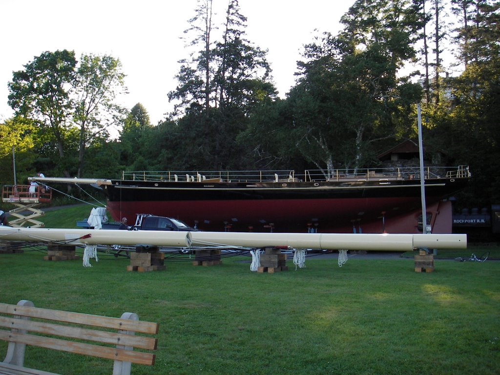 One of the stops recommended by out innkeep was the Rockport harbor. One of Rockport's master shipwrights had just finished building a Bermudian Schooner for the Bermuda Sloop Foundation. She was christened The Spirit of Bermuda and is based on the traditional 19th century Bermudian sailing vessels. According to news articles, she is not a replica; she is a new sailing vessel based on traditional designs and is full of high-tech gear.
 Her three masts are made of carbon-fiber and were built in Concord, MA. The man who built them was supervising the riggers when H and I coasted into the parking lot. He was graciously answering an onslaught of questions from passers by. If I remember correctly, he said each mast weighed one ton and that the walls were more than an inch thick at the base. He felt pretty confident that you could take a baseball bat to one of them and do more damage to the bat. Imagine doing that to your paddle or lightweight hull...
The Bermudians are picking her up on the 13th of August and will sail her back to Bermuda. Once there, she will be used to train Bermudian children to sail.
Sunday, August 06, 2006
Fire me up a Lobster
H and I headed north for a week of communing with nature. Our first stop was the Beal Island camp just outside of Bath, ME. Beal Island is a small island owned by the AMC and is associated with the AMC's Knubble Bay hut. Sandwiched between the Lowers Hell Gate and the Little Hell Gate, the island has wilderness camp sites for 30+, a four stall bif, a fire ring, and tables for a kitchen. At extreme high tides the fire ring and kayak parking can be under water, so there are also places to tie up kayaks.
The weekend started with the drive up on Friday. To break up the doldrums of a long highway drive we made a few stops.
The first stop was a Kittery Trading Post to return the evidence of an ill fated tent quest and acquire a brain box to safeguard my knoggin from being knocked around by rocks. We figured it would take a 1/2 hour. Two, or so, hours later we walked out of there with the brain box, two pairs of matching paddling shoes, a seat for H to use on the beach, and a camp coffee maker. The place is worse than REI for gear heads in a hurry.
The next stop was a rest stop for some healthy food. Popeye's and Cinnabon make for a great lunch. Just don't order naked chicken and expect it in a hurry. I could have eaten twice before H got her naked wings.
We also made a very quick stop at L.L. Bean to pick up a solar powered Nalgene (http://www.sollight.com/products/lightcap.cfm). To ensure a speedy stop, H forbad me to enter the main Bean building. I was only allowed a quick relief trip.
When we finally arrived at the Knubble Bay hut, we had to pack up our boats for the short trip over to the island. I've packed up my Seaward several times, but never the Q-Boat. H was in a similar situation. Fortunately, everything fit in the boats. Oddly the 16' Capella carried more than the 18' Valley. The Valley was close to being submerged and it only had the tent and my clothes for the weekend...
Mike K. was on hand to provide a good lesson in over packing. When we arrived, he was working on packing his stuff into his P&H Quest. When we shipped out, he was still figuring out where everything was going to fit. Rumor has it he had to leave the kitchen sink in his car:)
Saturday started off bright and early with a fantastic breakfast spread: sausages, fruit, and pancakes. After we were fully fueled, the leaders laid out the paddle plans. Due to the size and diversity of the group, we split into three groups: "advanced", "intermediate", and "beginner". There was an attempt to form a breakaway group, but the leaders deftly squelched it. The AMC is very much about group cohesion and plans. It is a little foreign to RICKA paddlers, but the leaders on this trip were very good about not allowing this to make things feel controlled.
H and I set out with the advanced group and figured that if things got too rough we could fall back to the intermediate group. The group was heading down to Reid State Park which is a seven mile trip in pretty sheltered waters. The current and the winds were with us the whole way and we flew. It was almost too easy.
Reid State Park is excellent. It has a rocky beach along the Sheepscott, a long stretch of sandy beach along the Atlantic, and Ice Cream.
We took a quick lunch break on the rocks--the bugs ruled the picnic area--and basked in the sun before setting out for a pleasant return voyage. The tides were supposed to turn and wash us back to the camp where we would be treated to lovely lobster bake.
To make the return trip a little more interesting, the advanced group decided to cross the Sheepscott and check out a lighthouse. It would add a scant few miles to our trip and provide some varied conditions.
The crossing was the first sign that things were not going to go as advertised. There was a fair bit of wind and some chop. Also, there was a contingent of slow paddlers drawing things out. Once across the river, we regrouped and took a brief and undignified bathroom stop.
The return trip was picturesque, but long. Sadly, the tide never turned in our favor. The tides in the area are difficult to predict. The combination of rivers and complicated ocean bottoms make the tides do interesting things.
I'm not a lobster eater, but H reported that the lobster was "to die for". The leaders provide me a delicious piece of tuna as a substitute. Throughout the evening, we had the opportunity to meet and chat with new folks along with catchin' up with some RICKA folks we had not seen in awhile (Barbara, Beverly, Bill R.). The night ended with the usual singing around the campfire, led by Anna who corraled the small few still awake.
On Sunday, we had a breakfast of eggs and bacon and then packed up. The plan was to get all the gear back to Knubble Bay and then do a short paddle.
After getting all of the gear and the canoes back up to the hut, most of the group paddled around the back side of Beal. The paddle provided some great opportunities to test the Q-boat in currents and waves. The Lower Hell Gate was running at a good clip and there was a fair amount of boat traffic. The combination produced some standing waves and fun conditions. For me it was fun, for some of the other paddlers it was a trying experience. They all made it through without a hitch, but there were a few white faces.
The area behind Beal was serene. There were some opsrey nests and several small islands.
We returned through Little Hell Gate on the other side of Beal.
Once back at Knubble Bay, we hauled the kayaks up the stairs, loaded up, and hit the road.
The leaders put on quite a spread and did a fantastic job.
Subscribe to:
Posts (Atom)